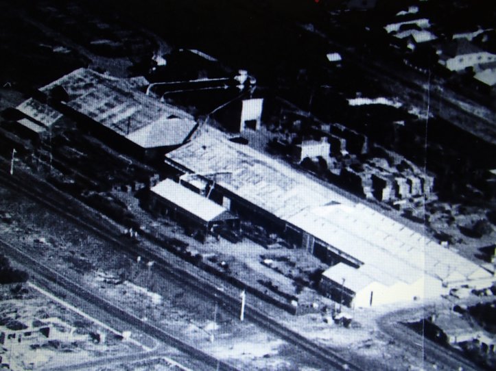
The land bordered by Miller Street, Beatty Avenue, Mint Street and the railway line in East Victoria Park was previously the State saw mill site before being sold to Hawker Siddley for use as a timber mill.
The Hawker Siddley site was re-purchased by the State Government to accommodate the relocation of the East Victoria Park Primary School, from its position on Albany Highway. The primary school site between Sussex Street and Albany Highway was sold to a private developer and is now the site of the Park Centre.
The state government’s plan for the Beatty Avenue frontage was the East Victoria Park Primary School and a state housing development of similar size to Brownlie Towers’.
Parkland is an essential element within the urban setting particulary with the state government planning to increase the Town’s resident lots by many thousands in the next few years.
Plans to accommodate this projected density, with a limited availability of vacant land means a number of outcomes, including more subdivision of current residential lots or higher density of two, three, four or maybe five storey residential blocks.
With this in mind the existence of the Town’s suburban backyards will dramatically decrease.
This is where public open space becomes an essential part of the urban setting and planning.
In the late seventies, I did a fair amount of research into the Town, identifying the number of empty retail shops along Albany Highway (about 45 shops) and the amount of parkland around the Town.
With the closure of the saw mill I thought a portion of the land would make a great passive recreation space. At that point between the railway line and Shepperton Road, public open space consisted of the Duncan Street/Sunbury Road Reserve and Kate Street Reserve.
During the early eighties I made enquiries through private channels and through the Perth City Council (PCC) to see if part of the land in Beatty Avenue could be used for parkland. The government positioned the EVPPS at the Mint Street end of the site away from state planning & Main Roads’ proposed four lane roadway and bridge (now Miller’s Crossing) along Kent and Miller Street.
In October of 1982 the Premier Sir Charles Court wrote to the PCC Town Clerk Mr Edwards offering free of charge four lots of land adjacent to the road reservation along Miller Street. This letter remained in the “IN tray” of one of the valuers of the City until February 1983. Eventually the PCC paid the then state government for the lots.
At no cost to the State Government, The Perth City Council undertook the major task of removing the industrial concrete plinths and mounts from the site which once supported a major proportion of the saw mill’s machinery. Hundreds of tons of concrete were broken up and carted away, some of the concrete being cut from 2 meters underground.
In the process, the PCC also removed major pieces of concrete in the area that came under the roadway reservation.
The PCC then established the park covering the whole lot from Miller Street to the boundary of the Park Primary School and the State Housing Commission land.
Brownlie Towers in Bentley in the 1970’s and 80’s had become a centre of anti social behavior. A state government decision to pass on the four lots to the Perth City Council was I believe due to the then State Premier Sir Charles Court not wanting a similar social disaster to emerge under his watch.
During the 1990’s the Council and local residents fought to reduce the reservation of the proposed four lanes along Kent, Miller Street and Roberts Road to a two lane road.
We eventually achieved that goal which is why the bridge “Miller’s Crossing” is only two lanes.
The community and the Town Council did not want our Town dissected by a major road.
A number of houses along Kent Street, between Albany Highway and Berwick Street, would have been demolished if the bridge was expanded from its present two lanes to four.
For 33 years since 1984, both the City of Perth and the Town of Victoria Park have maintained the whole parcel of land from the primary school boundary to Miller Street.
The sites on the opposite side of the railway line adjacent to Roberts Road and Bishopgate Street should also remain as public open space.
The road reservation adjacent to the old Lathlain/Carlisle bowling club site should also be lifted and gazetted as public open space.
I believe with the loss of previously proposed parkland now occupied by a semi private football ground, any already established open spaces should be retained.
With State Planning proposing to zone these lots to ‘Residential’ the land adjacent to Roberts Road and the old bowling club site as part of the road reserve could be under threat in the future.
We should be planning for the future not for the bottom budget line being foisted on the Town by state government departments.
What is the Town of Victoria Park council doing to protect this parcel of land?
